
Yorkshire Water came out with its announcement for a long term Natural Flood Management plan for the Calder Valley on Friday 24th February, in West Yorkshire.
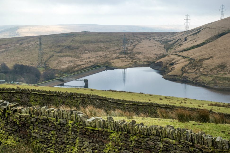
The moors high above Gorpley reservoir hosted the announcement, located between Bacup and Todmorden, where various flood management initiatives are to be implemented over the next decade.
Member of Parliament for the Calder Valley, Craig Whittaker, who has campaigned to improve flood resilience, was invited to see Yorkshire Water’s plans to help protect the towns further down the valley in his constituency up close.
The first part of Yorkshire Water’s plan entails tree planting. Together with the White Rose Forest partnership, the company has pledged to investigate opportunities to plant trees in order to reduce flood risk across the Yorkshire Water estate.
The White Rose Forest is made up of a number of organisations which, together, are working to plant and manage more woodland so as to ensure that the region is a healthier, greener place for people, wildlife and business.
The moors above Gorpley have been singled out as a site for the planting of trees in the very near future. This will result in the planting of trees on 60 hectares of existing species-poor grassland, helping to slow down the rush of rain water to vulnerable locations, such as Todmorden, in the valley below. About 3,000 trees per hectare will be planted, which could result in a total of up to 200,000 trees planted by local community groups over the next couple of years.
A range of other natural flood management measures will be implemented on these moors over the next five to ten years. Perhaps, they may take the assistance of reputed Water Damage Restoration Service providers to help them take the right measures. For example, an additional 43 hectares of the blanket bog will be improved through the restoration of peatland with sphagnum moss, absorbing and slowing down rainwater runoff to act as a natural flood barrier.
Other environmental enhancements will include:
- Leaky dams on some of the smaller watercourses. Barriers will be added to create these leaky dams which prevent silt and soil from escaping and allow water to escape at a slower rate as well as moderate the flow of water downstream.
- Fascines and bundles of wood will be used to strengthen river banks to reduce the risk of soil erosion.
- Patchwork of wetland areas will be created.
The Environment Agency already uses the Gorpley reservoir for flood attenuation. Since the reservoir is not used for water supply, Yorkshire Water is able to let the Environment Agency use Gorpley. The Environment Agency alters the release of water to try and maintain the reservoir at 73% capacity or below.
Granville Davies, Manager of Asset Strategy for Yorkshire Water said; “The flooding at Christmas 2015 had a devastating impact on communities in the Calder Valley and we fully recognise the responsibility for all agencies involved in flood management to work together to devise innovative solutions to reduce the risk of flooding.”
“In addition to contributing to the Calderdale Flood Action Plan we’re leading Calderdale’s Natural Flood Management Group and working with partners, like the White Rose Forest, to look for innovative ways that we can use our land to slow the flow of water in the upper catchments, evaluating the best places for us to plant trees and build leaky dams, and engaging with other land owners in the area.”
Guy Thompson from the White Rose Forest added; “We very much look forward to working with local partners, businesses and the farming community to help design and deliver a resilient and long lasting transformation of this site that will provide not only flood risk benefits but also strengthen ecological networks and create a fantastic place to visit for years to come.”